The Spokane River Dried Out This Summer. But Why?
Part 1 of 3: The River Went Dry
Two Augusts in a row, a mile and a half of the Spokane River disappeared. Drought and low snowpack seem like obvious answers. The measurements say there is more to the story.
By Jon Peters, Founder and General Manager, Irrigation Managers. Former agronomist and Certified Crop Adviser, 33 years in irrigation and agronomy.
As of October 13, 2026. The Spokane River has gone dry below Barker Road in Spokane Valley for two consecutive summers.
Two summers in a row, the Spokane River has run dry in August. In 2025 a stretch below Barker Road disappeared in the third week of the month. People who had walked that river for decades had never seen it, and the dead bass and crayfish in the leftover pools told the rest of the story.[^1] Flows returned on September 2, about eight hours after the release from Post Falls Dam increased.[^1] This August it happened again, about two weeks earlier, and the dry stretch, roughly 1.5 miles from Barker Road to Flora Road, stayed dry for weeks.[^2]
Key Takeaways
- The river went dry two years running. About 1.5 miles below Barker Road dried up in late August 2025 and again in early August 2026.[^1][^2]
- More water came through the dam, not less. Post Falls Dam released more water in the dry summers of 2025 and 2026 than in the dry summers of the 1990s and 2000s, when the river did not go dry.[^3]
- Downtown flows were higher too. The river carried more water through downtown Spokane in late August 2025 and 2026 than in the dry years of the 2000s.[^3]
- Snowpack matters, but it does not settle the question. A poor snow year pulls the dam's summer release down to 500 cfs, yet 2021 had nearly the same release and the stretch stayed wet.[^1][^3]
- Irrigation belongs in the conversation. Summer is when the river runs lowest and irrigation demand peaks.
Where did the Spokane River go dry, and when?
A stretch of roughly 1.5 miles below Barker Road in Spokane Valley went dry in late August 2025, then again in early August 2026, about two weeks earlier in the season. In 2025, flows returned September 2, about eight hours after Post Falls Dam increased its release.[^1][^2]
| 2025 | 2026 | |
|---|---|---|
| When it went dry | Third week of August (confirmed dry August 21 to 23) | Early August, about two weeks earlier [confirm date] |
| Where | Downstream of the Barker Road trailhead on the Centennial Trail | Barker Road to Flora Road, about 1.5 miles |
| How long | About two weeks | Several weeks |
| When flows returned | September 2, after Post Falls release increased | [confirm date] |
Sources: Spokane Riverkeeper; The Spokesman-Review.[^1][^2]
Why is an irrigation company looking into this?
Because many of our clients draw their irrigation water from the aquifer, and we are responsible for, or contribute to, how they manage that water. When the explanation offered was drought and climate change alone, the data deserved a closer look.
I have lived around this watershed, Coeur d'Alene Lake and the Spokane River, for more than 50 years, and I have spent my career in agronomy and irrigation. So when the news highlighted drought and climate change as the primary cause, I figured there was more to the story and felt compelled to dig into the data.
Wasn't it just drought and low snowpack?
Low snowpack is part of the story, but the flow record shows it is not the whole story. A poor snow year lowers the summer release from Post Falls Dam to 500 cfs, yet 2021 had nearly the same release and the stretch below Barker Road stayed wet.[^1][^3]
Definition: cfs. Cubic feet per second (cfs) is the standard unit for river flow: the volume of water, in cubic feet, passing a point each second.
Some explanations came fast, but they did not get to the root cause for me: a winter with almost no snow, an early-season drought, hype about data centers, and irrigation water use. I watched that winter go by with almost no snow in the mountains. Snowpack was the explanation I kept hearing on the news, and it made me want to learn more.
What role does Post Falls Dam play?
Post Falls Dam is the only dam between Coeur d'Alene Lake and the dry stretch, so its summer release sets how much lake water enters that part of the river. Avista owns several dams on the Spokane River, but only this one sits upstream of Barker Road.
Under its federal operating license, the dam must release at least 600 cfs from early June through the Tuesday after Labor Day. If the lake falls below a set summer level, the minimum drops to 500 cfs.[^1] That is the mechanism by which a poor snow year reaches the river: less snowmelt, a lower lake, a lower required release. In 2025, releases were cut to 500 cfs on August 6.[^1]
The dam deserves a close look. But as the record below shows, the release alone does not explain why the river went dry in 2025 and 2026 and not in drier-looking years before them.
What does the flow record actually show?
The dam released more water, and more water passed through downtown Spokane, in 2025 and 2026 than in earlier dry summers when the river never went dry.[^3]
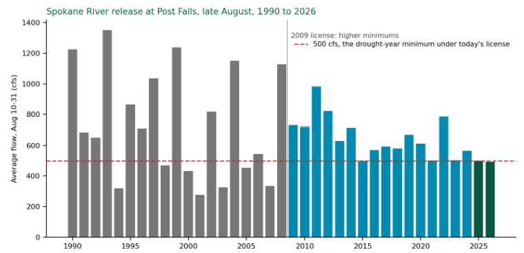 Source: USGS gauge 12419000, Spokane River near Post Falls, daily mean discharge, average of August 10 to 31 (2025 and 2026 are provisional).

Spokane River release at Post Falls, late August, 1990 to 2026. Average daily mean discharge, August 10 to 31. The dashed line marks 500 cfs, the drought-year minimum under the 2009 license. Source: USGS gauge 12419000, Spokane River near Post Falls, ID. 2025 and 2026 values are provisional.[^3]
Reading the chart: Before the 2009 license, several dry summers averaged well below 500 cfs, some near 300, and the river below Barker Road did not go dry. In 2025 and 2026 the release held at the 500 cfs minimum, and it did. 2021 was at about the same level and the stretch stayed wet.
| Finding | What it means |
|---|---|
| Post Falls Dam released more water in the dry summers of 2025 and 2026 than in the dry summers of the 1990s and 2000s. | The river did not go dry in those earlier years, on less water from the dam. |
| The river carried more water through downtown Spokane in late August 2025 and 2026 than in the dry years of the 2000s. | Water is reaching downtown. The dry stretch sits upstream of it. |
| A poor snow year pulls the dam's release down to 500 cfs. | Snowpack matters, mainly through the release. |
| 2021 had nearly the same release as 2025 and 2026. | The stretch stayed wet in 2021, so release alone does not predict a dry river. |
Manage a property that irrigates from the aquifer? The first step toward using less of it is knowing how much your landscape actually needs, zone by zone. Request a Water Use Analysis →
Why does irrigation belong in this story?
Summer is when the Spokane River runs lowest and when irrigation demand is highest. Those two peaks overlap in exactly the weeks the river went dry, which is why irrigation has to be part of an honest look at the cause.
That is not an accusation. It is a timing fact, and it cuts both ways: if irrigation is part of the pressure on the river in August, then better-managed irrigation is part of the relief. Water that a landscape does not need, applied on a schedule set once in spring and never revisited, is water that can be recovered.
What comes next in this series?
Part 2 and Part 3 follow the water from the dam to the dry stretch and look at what the data says about the cause.
- Part 2: [Title and link to come]
- Part 3: [Title and link to come]
How does Irrigation Managers help properties that irrigate from the aquifer?
Irrigation Managers manages commercial irrigation remotely using agronomy, not habit: each zone gets water when and how it is needed, based on plant demand, soil, and weather.
Every zone on a property is its own microclimate. Sun, shade, slope, soil, and plant material all change what it needs, and a single program across 80 zones is wrong in 79 different ways at once. Our AIM framework addresses that directly:
- Analyze. A Water Use Analysis establishes baseline need, peak demand, and seasonal adjustment for each site.
- Implement. Controller programming and scheduling built from measured uniformity, plant demand, and the legal watering window.
- Manage. 24/7 monitoring, alerts, ongoing optimization, and reporting against the baseline.
Service starts as low as $1 per zone per month, with full management and reporting as low as $5 per zone per month. Our team is led by a former Certified Crop Adviser and a Certified Landscape Irrigation Auditor.
Request a Water Use Analysis →
Frequently Asked Questions
Why did the Spokane River go dry near Barker Road?
A stretch of about 1.5 miles below Barker Road in Spokane Valley went dry in August 2025 and again in August 2026. Drought and low snowpack were the most common explanations, and a poor snow year does lower the summer release from Post Falls Dam. But flow records show the dam released more water in 2025 and 2026 than in dry summers of the 1990s and 2000s, when the river did not go dry, so the cause is more complicated than drought alone.
Did Post Falls Dam cause the Spokane River to go dry?
The record does not support that conclusion on its own. Post Falls Dam is the only dam between Coeur d'Alene Lake and the dry stretch, and in low-water years its required summer release drops to 500 cfs. However, the dam released more water in 2025 and 2026 than in earlier dry years when the river stayed wet, and 2021 had nearly the same release without the river going dry.
Was low snowpack the reason the Spokane River dried up?
Low snowpack contributed, mainly by lowering Coeur d'Alene Lake and pulling the Post Falls Dam release down to its 500 cfs minimum. It does not explain the whole event. In 2021 the release was nearly the same, and the stretch below Barker Road stayed wet.
Has the Spokane River gone dry before 2025?
Not that longtime river users remember. People who had walked the river near Barker Road for decades had never seen it dry before August 2025. The river also did not go dry in the dry summers of the 1990s and 2000s, even though Post Falls Dam released less water in those years.
Does landscape irrigation affect the Spokane River?
Irrigation belongs in the discussion because of timing: summer is when the river is lowest and when irrigation demand is highest. Many properties in the Spokane area irrigate from the aquifer. How much that matters for the dry stretch is the question Parts 2 and 3 of this series examine, and better-managed irrigation is one of the few parts of the problem property owners control directly.
References
[^1]: Katelyn Scott. The Summer the River Disappeared: Documenting the Spokane River's Dry Stretch. Spokane Riverkeeper, November 2025. https://www.spokaneriverkeeper.org/riverjournal/2025/11/13/the-summer-the-river-disappeared-documenting-the-spokane-rivers-dry-stretch
[^2]: Julia Pentasuglio. Once again the Spokane River has run dry, this time two weeks earlier than before. The Spokesman-Review, August 10, 2026. Via LEO Network: https://leonetwork.org/posts/show/5794A3CF-69C7-4E98-BF0D-244F367D131C [replace with spokesman.com original]
[^3]: U.S. Geological Survey. Spokane River near Post Falls, ID, gauge 12419000, daily mean discharge, August 10 to 31, 1990 to 2026 (2025 and 2026 provisional). Analysis by Jon Peters. https://waterdata.usgs.gov/monitoring-location/12419000/ [Add the downtown gauge used for the downtown-flow finding, likely USGS 12422500, Spokane River at Spokane, WA.]