The Underground River: Where the Spokane River's Water Goes
Part 2 of 3: Where the Water Goes
The water did not vanish. It went underground, into the aquifer, and the rate seems to have changed.
By Jon Peters, Founder and General Manager, Irrigation Managers. Former agronomist and Certified Crop Adviser, 33 years in irrigation and agronomy.
As of October 21, 2026. USGS flow and well data pulled October 7 and 8, 2026. 2026 values are provisional.
In Part 1, the numbers showed that Post Falls Dam released more water in 2025 and 2026 than in earlier, drier summers, and that even the river through downtown Spokane carried more water than in those years. A stretch upstream still dried up.
So where did the water go? Under the riverbed, and then back out again farther downstream. That relationship is not new. Hydrologists and many people who live here have long known how closely the river and the aquifer are tied, and USGS has been measuring the exchange for decades.[^1][^2][^3]
Key Takeaways
- The river feeds the aquifer, and the aquifer feeds the river. River leakage is the largest single source of water entering the Spokane Valley-Rathdrum Prairie aquifer, roughly half of all inflow.[^1]
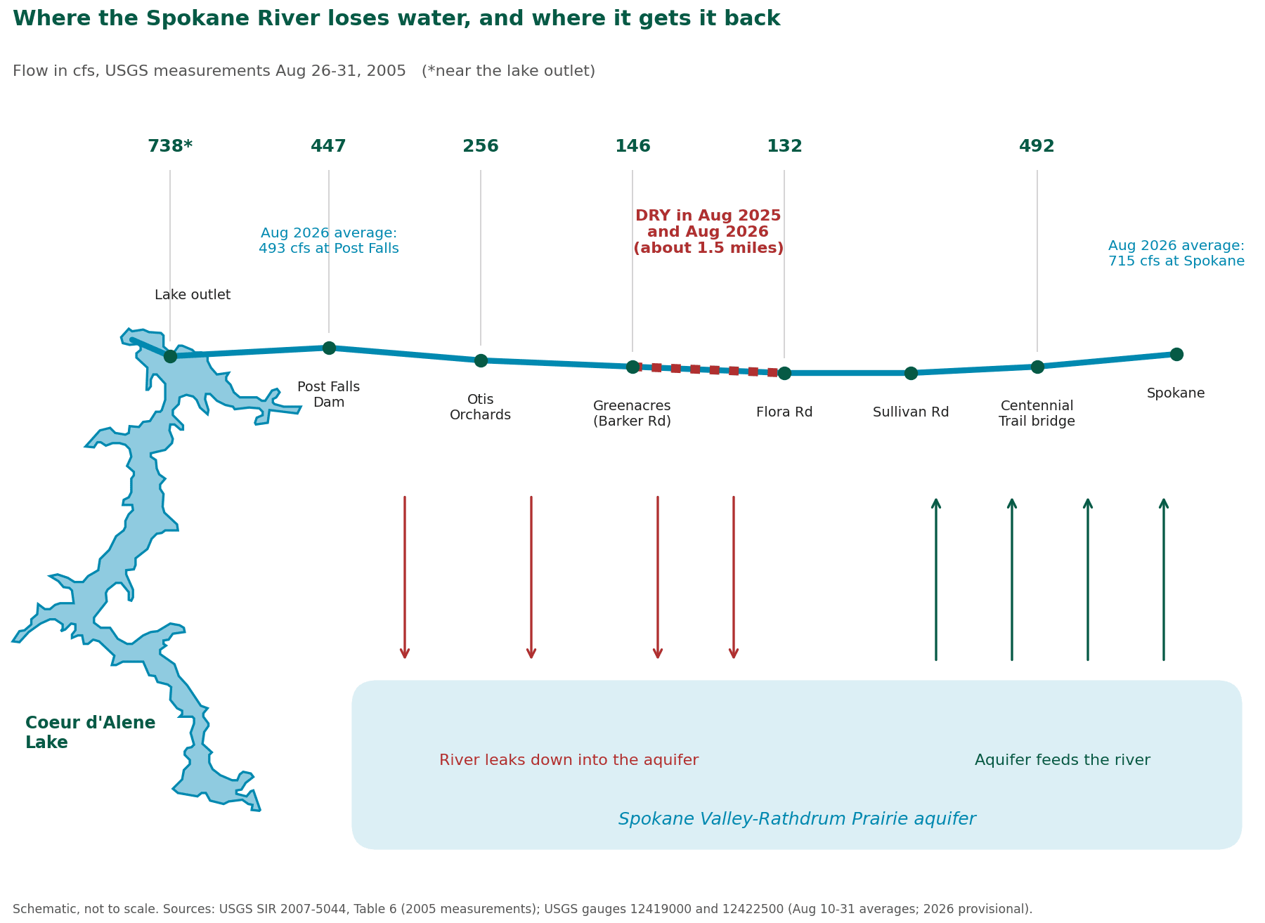
- Upstream, the river loses water. Downstream, it gets it back. From Post Falls toward Barker Road the river drains down into the aquifer; below Sullivan Road the aquifer returns it.[^3][^4]
- Aquifer levels are not the problem. Two long-record USGS wells show a modest slide since 2017 but levels well inside their historical range, with nothing that looks like a collapse.[^6]
- The rate of seepage appears to have changed. The last USGS seepage run, in 2005, measured 315 cfs lost between Post Falls and Flora Road. Riverkeeper estimates at least 500 cfs had to be leaving in 2025 to dry the river.[^2][^7]
- Nobody has shown why yet. A Spokane Community College seepage study due this fall will be the first measurement of where the water leaves since 2005.[^7]
How are the Spokane River and the aquifer connected?
The Spokane River and the Spokane Valley-Rathdrum Prairie aquifer are one interconnected system. The river leaks into the aquifer along its upper reach, and the aquifer pours water back into the river farther downstream.
By late August, the water running through downtown Spokane is mostly groundwater that has come back out of the aquifer. A consultant's estimate presented to the region's water providers this March put it at roughly 72 to 75 percent.[^4] As Ecology put it in August, "the river depends on the aquifer."[^5]
Definition: Spokane Valley-Rathdrum Prairie aquifer. The Spokane Valley-Rathdrum Prairie aquifer is the underground body of water beneath the Rathdrum Prairie in North Idaho and the Spokane Valley in Washington, and the main source of drinking water for the Spokane and Coeur d'Alene areas.[^4]
Where does the aquifer's water come from?
About half of the water entering the aquifer is leakage from the Spokane River, making the river its largest single source. Lakes supply about a fifth.[^1]
The USGS water budget for the aquifer (averages for 1990 to 2005, the most complete one available) breaks it down this way:
That 718 cfs is about 465 million gallons a day. One caution: the river number comes from one week of measurements in late August 2005, so treat the river's share as roughly half rather than an exact figure.
Definition: cfs. Cubic feet per second (cfs) is the standard unit for river flow. One cfs running for a day is about 646,000 gallons.
Where does the river lose water, and where does it gain it back?
From Post Falls down toward Barker Road, the river loses water to the aquifer because dry ground separates the riverbed from the water table. Around Barker Road that gap closes, at Sullivan Road the aquifer and the river bottom meet, and below Sullivan Road the aquifer gives the water back.[^3][^4][^8]
The trade between river and aquifer is lopsided from one stretch to the next. USGS wells in the Barker Road area show water anywhere from about 10 to nearly 200 feet below the ground, depending on the spot.
| Stretch of river | What the river does | Why |
|---|---|---|
| Post Falls to Barker Road | Loses water to the aquifer | Dry ground between riverbed and water table; water drains straight down |
| Barker Road to Sullivan Road | Still losing, gap closing | Water table rising toward the riverbed. The dry stretch begins here. |
| Below Sullivan Road | Gains water from the aquifer | Water table meets the riverbed; groundwater flows into the channel |
Definition: losing reach. A losing reach is a stretch of river where water leaks down through the riverbed into the ground below, so the river carries less water at the bottom of the stretch than at the top.
Here is the part that matters for the cause. Where the water table sits well below the riverbed, how high the aquifer is has little say in how much leaks out. The river drains at the rate the riverbed allows. That is one reason aquifer levels were an unlikely suspect. No published figure turned up for the exact depth to water under the channel at Barker or Sullivan Road. But I wanted to dig in a little to confirm, so I looked at what wells across the aquifer show.
Is the Spokane aquifer running low?
No. USGS records for two long-record wells show a modest slide since 2017, but levels remain well inside their historical range, with nothing that looks like a collapse.[^6]
A well works like a dipstick for the aquifer: the farther down you have to go to find water, the lower the aquifer. So a bigger number means less water in storage.
Spokane Valley well near Liberty Lake (readings back to 1921)
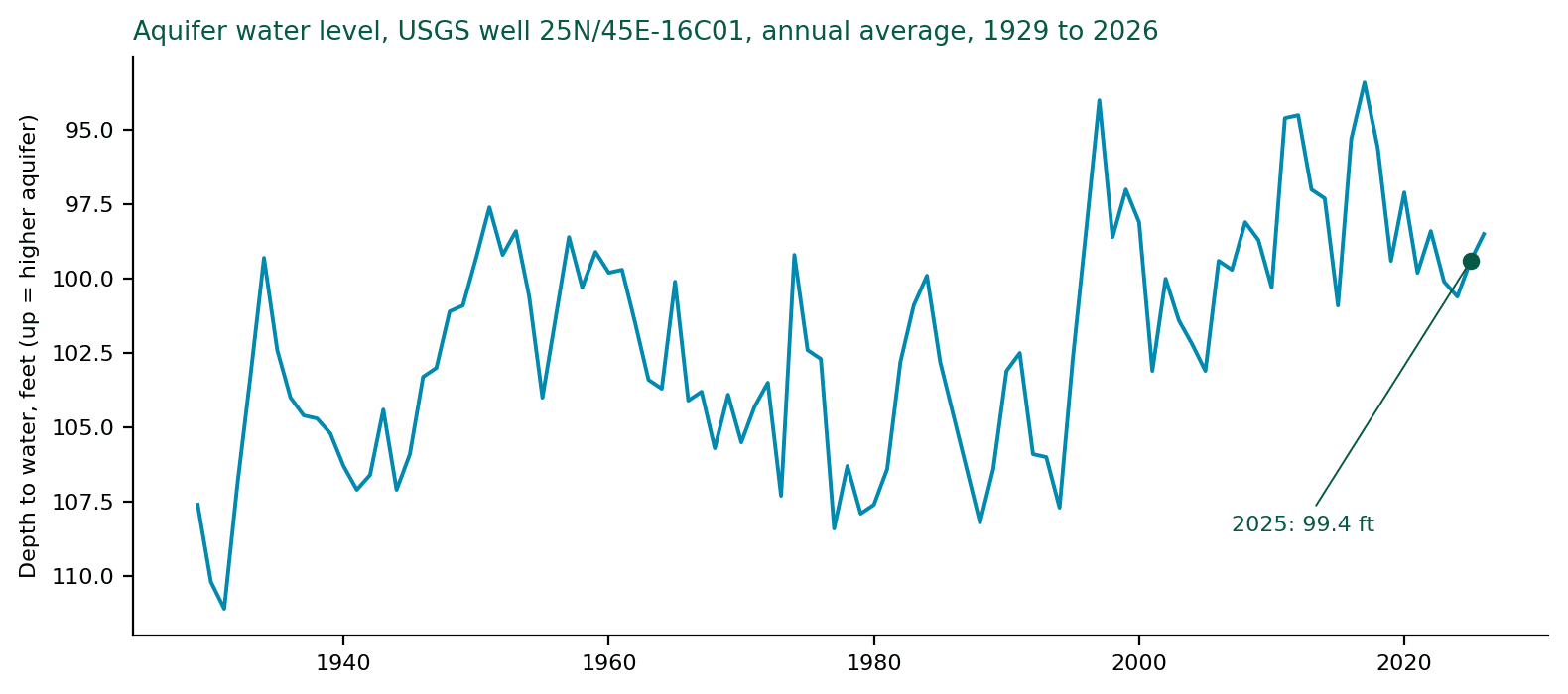
The 2025 late-summer low of 102.5 feet is shallower than the late-summer low of every year from 2001 through 2008. The water is about six feet lower than at the 2017 high, so there has been a modest slide, but it sits well inside the historical range.
Rathdrum Prairie well near Spirit Lake (readings back to 1971)
| Measure | Depth to water (feet) |
|---|---|
| Lowest years on record (1978 to 1994) | about 418 to 419 |
| 2025 annual average | 409.8 |
| Highest year on record (1997) | 393.8 |
Source: USGS field water-level measurements, well 475439116503401. Analysis by Jon Peters.[^6]
Two wells are not the whole aquifer, and no aquifer-wide report for 2024 to 2026 turned up. Nothing in these records looks like a collapse.
Irrigate from this aquifer? The water on your landscape in July is the same water the river needs in August. The first step toward using less of it is knowing how much your site actually needs, zone by zone. Request a Water Use Analysis →
What changed to make the river go dry?
What appears to have changed is seepage, the water that leaks down through the riverbed into the aquifer. The last USGS measurement, in 2005, found the river losing 315 cfs between Post Falls and Flora Road. Riverkeeper estimates at least 500 cfs had to be leaving in 2025 to dry the river.[^2][^7]
Definition: seepage run. A seepage run is a set of flow measurements taken at points up and down a river on the same days, to see how much water is lost or gained between each pair of points.
| Measurement | Water lost to the aquifer | Status |
|---|---|---|
| USGS seepage run, late Aug. 2005, Post Falls to Flora Road | 315 cfs | Measured[^2] |
| Same run, counting from the Coeur d'Alene Lake outlet | 606 cfs | Measured[^1][^2] |
| Spokane Riverkeeper figure for 2005 | 332 cfs | Riverkeeper's own figure[^7] |
| Spokane Riverkeeper estimate, 2025 | at least 500 cfs | Estimate, not a published measurement[^7] |
Nobody has shown why. Pumping close to the river and the weather have both been raised as possible factors.[^7] I would add a third: changes in the sediment moving through the riverbed.
The sediment idea is worth a closer look. Mining waste and other sediment have flowed into Coeur d'Alene Lake for decades, and cleanup since the 1990s may have changed how much sediment reaches the river. Whether that changed the fine silt on the riverbed, and whether a cleaner bed lets more water through, does not appear to have been studied. It sure piques my interest.
A seepage study by Spokane Community College's water resources program, working with Spokane Riverkeeper, is due this fall. It will be the first measurement of where the water leaves since 2005.[^7]
Where does irrigation come in?
The aquifer and our irrigation water are the same water. In summer a large share of what is pumped out of it goes onto landscapes and crops, and how much we pull out in July and August is one of the few parts of this system people can actually change.
We cannot change the snowpack or the seepage rate. We can change how much water we pull out in July and August. Many of our clients irrigate from this aquifer, so for us this is not abstract.
Part 3 looks at the numbers: what gets pumped from this aquifer, how much of it goes on landscapes, and what we can do about it.
- Part 1: The River Went Dry
- Part 3: Where Irrigation Fits [add link when live]
How does Irrigation Managers help sites that irrigate from the aquifer?
Irrigation Managers sets a data-based water target for each site and manages to it all season, so landscapes get water when and how they need it instead of on a schedule set once in spring.
The aquifer and the river are one system, so every site that irrigates from it, in Idaho or Washington, has a hand in what the river gets. If you manage a large irrigated site, the question to ask is how much water your site actually needs. Not a guess, and not an estimate based on how much you used last season. A number based on data. If you don't know your number, chances are you are over-irrigating.
Every zone on a property is its own microclimate. Sun, shade, slope, soil, and plant material all change what it needs. Our approach is called AIM: Analyze, Implement, Manage.
- Analyze. We map the irrigated area and use historical weather data to build a monthly water target for the site.
- Implement. Controller programming and scheduling built from measured uniformity, plant demand, and the legal watering window.
- Manage. Real-time adjustments to match actual weather, 24/7 monitoring, and management to the full-season target, with reporting against the baseline.
Service starts as low as $1 per zone per month, with full management and reporting as low as $5 per zone per month. Our team is led by a former Certified Crop Adviser and a Certified Landscape Irrigation Auditor. There is no obligation, and we are glad to walk you through it. Call 1.800.473.7673 or send a message.
Request a Water Use Analysis →
Frequently Asked Questions
Where does the Spokane River's water go when it dries up near Barker Road?
It goes underground. Between Post Falls and the Barker Road area, the Spokane River sits above the water table and leaks down through its bed into the Spokane Valley-Rathdrum Prairie aquifer. Below Sullivan Road the aquifer returns that water to the river, which is why downtown Spokane still had flow in August 2025 and 2026 while a stretch upstream was dry. By late August, most of the water in the river through downtown is groundwater.
Is the Spokane Valley-Rathdrum Prairie aquifer drying up?
The available records do not show that. A USGS well near Liberty Lake with readings back to 1921 averaged 99.4 feet to water in 2025, shallower than its 1980s average of 104.5 feet and far from its 1931 low of 111.1 feet. A well near Spirit Lake with records back to 1971 shows the same picture. Levels have slid about six feet since a wet-decade high in 2017, but remain well inside their historical range. Two wells are not the whole aquifer, and no aquifer-wide report for 2024 to 2026 has been published.
How much water does the Spokane River lose to the aquifer?
USGS measured 315 cfs lost between Post Falls and Flora Road in late August 2005, and 606 cfs counting from the Coeur d'Alene Lake outlet. That 2005 seepage run is the most recent published measurement. Spokane Riverkeeper estimates at least 500 cfs had to be leaving in 2025 for the river to go dry, but that figure is an estimate, not a measurement.
Why would the Spokane River lose more water now than it did in 2005?
Nobody has shown why. Pumping close to the river and the weather have been raised as possible factors. Jon Peters of Irrigation Managers has raised a third question: whether decades of cleanup on Coeur d'Alene Lake changed the fine silt on the riverbed, letting more water through. That has not been studied. A Spokane Community College seepage study due in fall 2026 will be the first new measurement of where the water leaves since 2005.
Does irrigation in Spokane Valley and North Idaho affect the Spokane River?
The aquifer that feeds the river in late summer is the same aquifer most Spokane Valley and Rathdrum Prairie sites irrigate from, and summer pumping peaks in the same weeks the river runs lowest. How much irrigation matters to the dry stretch is the subject of Part 3 of this series. What a property manager controls directly is how much water a site pulls out in July and August, and the first step is knowing how much the site actually needs.
References
[^1]: Kahle, S.C., and Bartolino, J.R. Hydrogeologic Framework and Ground-Water Budget of the Spokane Valley-Rathdrum Prairie Aquifer, Spokane County, Washington, and Bonner and Kootenai Counties, Idaho. U.S. Geological Survey Scientific Investigations Report 2007-5041, Table 2. https://pubs.usgs.gov/sir/2007/5041/table2.html
[^2]: Hsieh, P.A., and others. Ground-Water Flow Model for the Spokane Valley-Rathdrum Prairie Aquifer, Spokane County, Washington, and Bonner and Kootenai Counties, Idaho. U.S. Geological Survey Scientific Investigations Report 2007-5044, Table 6. https://pubs.usgs.gov/sir/2007/5044/
[^3]: Caldwell, R.R., and Bowers, C.L. Surface-Water/Ground-Water Interaction of the Spokane River and the Spokane Valley/Rathdrum Prairie Aquifer, Idaho and Washington. U.S. Geological Survey Water-Resources Investigations Report 03-4239. https://pubs.usgs.gov/publication/wri034239
[^4]: Porcello, J. (GSI Water Solutions). Presentation to the Spokane River Forum Water Breakfast, March 31, 2026. https://spokaneriver.net/wp-content/uploads/2026/04/Porcello-H2O-Bkfst-2026-03-31-3.pdf. See also Spokane Aquifer Joint Board, 2023 SVRP Aquifer Atlas. https://www.spokaneaquifer.org
[^5]: Washington State Department of Ecology and Avista. News release, August 7, 2026. [Add URL]
[^6]: U.S. Geological Survey. Field water-level measurements, wells 474011117072901 (25N/45E-16C01) and 475439116503401. Records retrieved October 7 and 8, 2026; annual averages calculated by Jon Peters. https://api.waterdata.usgs.gov
[^7]: Schultz, J. How to Study a Dry River. Spokane Riverkeeper, July 2026. https://www.spokaneriverkeeper.org/riverjournal/2026/7/27/how-to-study-a-dry-river. An advocacy group; the 332 and 500 cfs figures are its own.
[^8]: Ralston, D.R., and Johnson, G.S. Report to the Idaho Water Resource Board, 2015, on 2010 Spokane River flows at Post Falls, Greenacres, and Spokane. https://idwr.idaho.gov